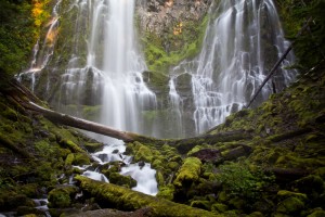
Proxy Falls is a gorgeous 226 foot veil waterfall that cascades down a wall of mossy columnar basalt. Accessed by a short half mile to mile hike directly off McKenzie Highway 242, Proxy Falls is easily one of the most photogenic waterfalls in Oregon.
 Location: Proxy Falls is located approximately 65 miles from Eugene, 6-1/2 miles from the junction of Highway 126 (The McKenzie River Byway) and Highway 242 (McKenzie Pass). The parking area is well signed with a large pull out right before the road turns sharply and gains significant elevation.
Google Maps – Eugene to Proxy Falls
Adventure Specifics: The waterfall is accessed by two hiking trails, the official signed trail to the right and is a ¾ mile hike over moderate to easy terrain (not ADA accessible). The alternative route is ½ mile with slightly more difficult terrain and not as rewarding of a view. If you are visiting around sunset I highly recommend the official path to the right.
Warnings: During the cooler months, the paths around the falls can be snowy and icy. Use caution. Also check road conditions before heading out, this area gets a lot of snow and experiences seasonal closures. Access to the falls may be closed from November until July.
What to Bring: A camera, water resistant jacket (if you plan on getting near the falls), and good walking shoes.
Amenities: Pit toilets, paved parking, paved walking paths, picnic tables, and garbage receptacles.
Best Times to Go: Proxy Falls are generally the best between June and early November and access to the falls may be closed off due to the seasonal closure of McKenzie Highway 242.
Nearby: Linton Lake, Linton Falls, Dee Wright Observatory, Scott Lake, Three Sisters, Belknap Hot Springs and Resort